|
|
|
Keys and Legends
The use on maps of keys or legends (the two terms are interchangeable to describe the various abbreviations, colours, type styles and symbols) is now taken for granted. They were not, however, used by Ordnance Survey until the 1:10,560 sheets first appeared in the 1850s and did not find their way onto the one-inch maps until the 1880s.
At the time the one-inch maps were conceived, the landscape of Britain was largely empty and most features could be either named or pictorially implied. By the time the Old Series had been completed and revisions to it contemplated, however, the diversity of the human landscape had changed considerably, as had the uses to which the maps were being put. The use of ever more sophisticated keys thus became necessary in order to make the maps intelligible, useful and commercially viable.
As a result, they provide a key to more than just the details shown on the maps: they offer an insight into the age that created them. Even a brief study of a map key will show which features were then deemed important and also those which were sufficiently abundant to require symbolic depiction.
The comments that follow for each of the series covered relate in general only to the keys. For more detailed information on each series in general please see the relevant links on the menu.
One inch to the mile (1:63,360) maps
Old Series
No legends existed on the original Old Series maps. Abbreviations and symbols were always employed but their usage, depiction and meaning evolved during the 70-odd years it took to complete the project. Although a comprehensive legend is therefore impossible, some signs were (with minor variations) consistently used: these are shown here.
Note that as Cassini’s maps have been created by joining original sheets which may have been published at different dates, it is possible that any one Cassini map might contain more than one style of abbreviation or symbol (and, indeed, other variations of design).
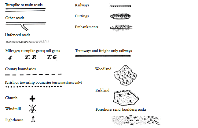
The publishers would like to thank Dr Richard Oliver (B.A., D.Phil., F.B.Cart.S.) of the University of Exeter for his invaluable help in creating this legend and other aspects of this article. This legend © Cassini Publishing Ltd & Richard Oliver.
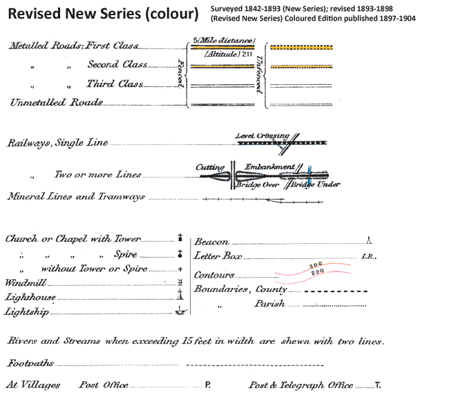
Revised New Series
The three most obvious differences between the style and content of this and the Old Series were the (partial) use of colour, the introduction of contour lines (as well as hachures) to depict high ground and the extraordinary growth of the railways. Roads were also graded, although without any great precision, and the distinction between church towers and church spires recorded.
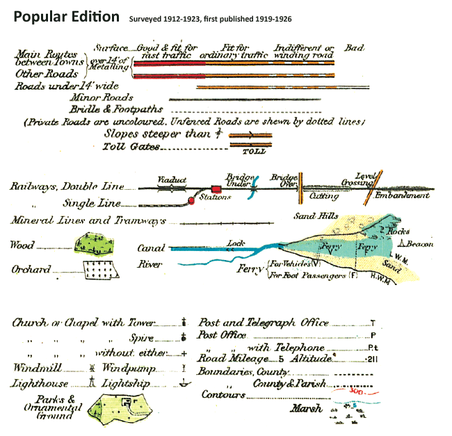
Popular Edition
This was the first full-colour map of Britain and with it came a full-colour legend. For the first time, the roads were classified by their suitability (or otherwise) for motor cars. Hachures had by this time disappeared, with contours, at closer intervals, superseding them in the depiction of high ground.
New Popular Edition
These maps, produced just after the Second World War, show that travel by road was now the dominant method of transport. Ministry of Transport classifications were now specified for roads, which were now numbered. Note also the new of symbols describing with the equally recent proliferation of the telephone and the wireless.

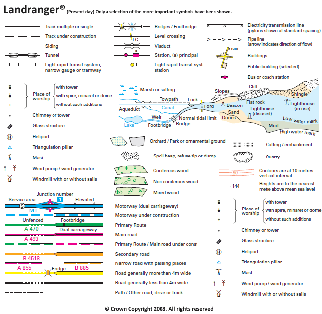
Present Day Landranger
The current Ordnance Survey 1:50,000 mapping (represented, in most people’s minds, by the Landranger® series) is the definitive survey and expression of the landscape at this scale. The key is abbreviated here, for reasons of space, but many of the abbreviations and symbols used have passed into the collective national consciousness. Features as diverse as shopping centres and disused railway lines, car parks and stone monuments, rock screes and picnic sites are all included, indicated by an increasing range of symbols and abbreviations.
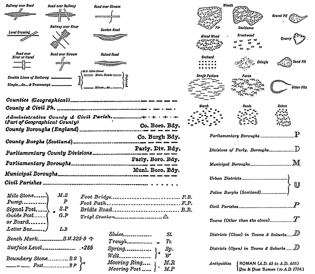
1:10,360 and 1:2,500 maps
The keys used for the 1:2,500 and 1:10,360 (referred to here and elsewhere as the 1:10,000, the nearest metric equivalent scale to which they have been enlarged) County Series maps were essentially the same; although, of course, more information was shown on the former than the latter. At these levels of detail, virtually every man-made feature, and many natural ones, needed to be displayed from the outset, and so these keys were not subject to the same variation that evolved over time with the smaller-scale one-inch maps discussed above.
The usage of various numbers that appear on these sheets, particularly the more detailed 1:2,500, are worth clarifying.
· On both scales, a number in italics next to a dot refer to spot heights above sea level, in feet.
· On the 1:2,500 maps, acreages of fields are shown by numbers followed by three decimal points.
· Other numbers, with no decimal points, are the field numbers; further information on these was shown in Area Books (also known as Books of Reference) which were published separately until the 1880s.
· A cursive ‘S’ means that two or more fields were regarded as being one for these purposes, with the area and numberings applying to both or all fields collectively.
These maps also showed much more in the way of administrative divisions than was possible on the 1:50,000 maps and different type styles were used for each. Single specimen letters are shown for each style on the map key.
The precision and scope of the County Series maps is breathtaking. The combination of painstaking attention to detail, adherence to strict and consistent guidelines, technical accuracy and artistic skill are manifest in every sheet of these remarkable maps. As with all Ordnance Survey maps, a glance at the map keys will show the ambitions and intentions of the surveyors and cartographers which were abundantly fulfilled by the quality of the maps themselves.
|